Storm Chasers Log: Fast Motions, Wrong Roads, 10-3-23
Brian Neben
Editor/Director of Digital Content – Central Nebraska Today
KEARNEY — I was at the mercy of the rural Nebraska road grid on Tuesday and it was not kind to me in the face of storm motions of 40 to 50 mph.
Looking at the forecast for Tuesday, Oct. 3, it was clear this was likely the last best chance for any local chasing in 2023. The system moving through the area would usher in a major pattern change and finally make it feel like autumn had arrived.
The days preceding Oct. 3 had been unseasonably warm and featured strong southerly winds transporting moisture north.
A large upper-level trough was moving in from the western United States and would cross the Rockies on Tuesday. This would induce a surface low pressure area to form over the northern Plains that would serve to further increase the dew points.
An attendant cold front with this system was draped across Nebraska and would progress eastward during the evening. This would serve as the primary forcing mechanism for convection later in the afternoon.
What I had noted was the upper level winds were more parallel to the cold front, which would promote storms congealing into a line, rather than staying discrete, which is more favorable for tornado development.
Tornadoes can still form within a line of thunderstorms, but they are often short lived, and difficult to document.
It was clear there was going to be an initial round of more isolated cells, followed by clusters of thunderstorms growing into a meso-scale convection system, an MCS. In a nutshell, the opportunity was going to be short.
Unlike my last chase in September, there was plenty of upper-level air movement and storm motions were going to be noticeably quicker.
I waited out the first few rounds of showers that were nothing but bait, the real show was going to occur in the afternoon.
Sure enough, by 2 p.m. into 3 p.m., storms began to fire to the southwest of the Tri-Cities. An earlier round of convection wasn’t able to tap into the instability present and the able wind shear was actually hampering storm development.
There was a cell on the leading southern edge of the developing convection that had my attention. This storm had clear air in front of it and wouldn’t be hampered by other storms, which was happening to practically every other cell behind it.
I held position in Kearney long enough to see the cell move up through Gosper County, but by 3:30 p.m., it was clear I couldn’t wait any longer.
I set off west toward Elm Creek, it was clear I could cut off the core of the storm somewhere near the area. As I neared the community, I could start to make out a large tail cloud, feeding the storm with additional moisture.
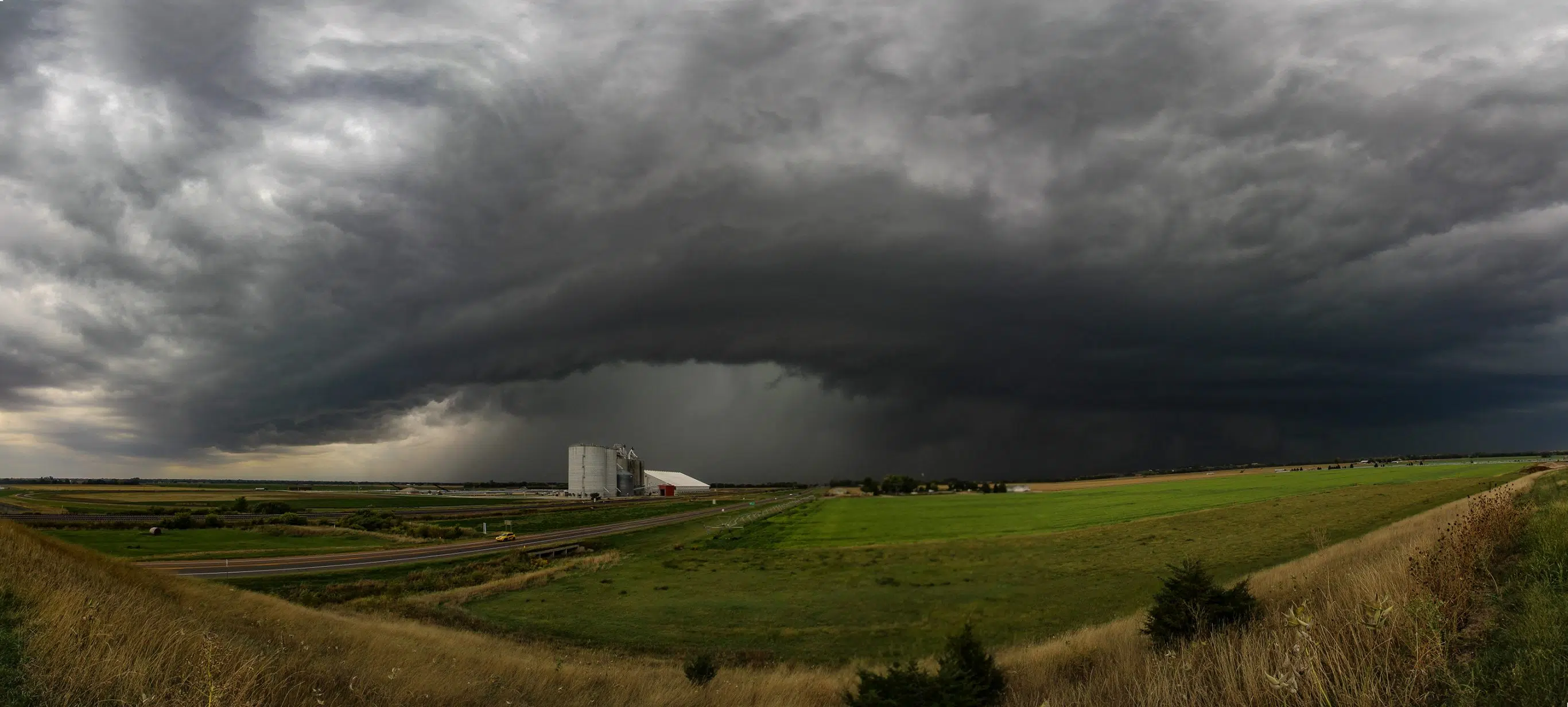
I pulled over on the Elm Creek overpass for a better vantage and the view to the west couldn’t have been better – the dark forbidding edge of the storm complex with a bowing out segment that designated where the hail/rain core was.
I proceeded north on Highway 183, trying to keep up with the complex but that soon became difficult. It was clear the heavy core of precipitation was going to cross the highway.
I stopped for a second to grab a photo of the imposing wall of gray, but the arrival of the rain forced me back into the car and I headed back south to give the storm some room.
The storm was proceeding rapidly off to the northeast and I jumped back on Highway 30 trying to keep up with it, turning north at Odessa to try and keep pace.
My instincts about the storm had been correct, it eventually took on enough mid-level rotation for it to gain a tornado warning as it headed toward Pleasanton and Ravenna.
But I had a dilemma, I was southwest of the hook area where I could get an eye on the storm’s base and the road I was on was going to terminate at Highway 40. The highway runs in a northeast-southwest direction, not in the direction that I needed.
I usually try to avoid gravel roads as they can turn to a soupy mess in heavy rains but I decided to chance it. I turned north and was only able to gain a little ground on the storm but it soon became clear I couldn’t go fast enough and the storm motion was too fast.
It stung a little that even when I finally came to a stop, my view of the storm was less than picturesque.
However, I was about to have a bigger issue – additional storms were rapidly developing to my south and moving north at the same speed as everything else.
My view to the south was foreboding, just a black wall that was rolling toward me. As I continued back to Highway 40, I could make out more features, including a concentrated gray downdraft that almost certainly contained hail.
It was headed right for me.
There was nothing I could do but take advantage and snap some more photos before making my way south, which felt a little like approaching the Valley of the Shadow of Death.
The rain began to fall around me but suddenly there was nothing but a gray wall in front of me and then in an instant, the rain was so heavy I lost sight of the road.
The lizard part of my brain wanted to panic, but I came to a stop for a moment to get my bearings. It was clear the rain wasn’t letting up and not wanting to get stuck on a muddy road, I proceeded gingerly south.
It seemed to take an eternity but I finally found Highway 40 and was able to proceed back west headed for home. I couldn’t chase what I couldn’t see.
There was an issue though, storm clusters were forming into the forecasted line and there was enough rotation over Phelps County that a tornado warning was issued.
It wasn’t hard to draw a mental line and could see this area of rotation would pass directly over my home in Odessa.
I had faced a similar situation in June 2021 when a tornado warned storm passed directly over my home. I always go out hoping to see a twister, but on both these occasions – it was the last thing that I wanted to happen.
I managed to get back home just ahead of the tornado warned area and tried not to drown getting back in the house, given the torrential downpour that was occurring.
After a few tense moments, it was clear the rotation had dissipated and the warning was allowed to expire. My biggest fear is facing a rain-wrapped tornado that I cannot see, especially when it could hit your home.
The line of storms pushed quickly to the east and just like that, the sun was coming back out. I headed back out as the sunset in the west, illuminating the departing storms with hues of orange, purple and pink.
After five years of chasing I have learned to have a healthy respect for Mother Nature. Sometimes you can make the right plays, choose the right storm, but a combination of quick storm motions and an uncooperative road network can throw your best laid plays awry.
Throw in a tornado warning scare close to home and it makes it clear how little control we actually exercise over Nature.
In the meantime, my 2023 storm chasing seems to be at a close, I may try to hibernate until spring 2024.

