KEARNEY — With the temperatures dipping below into the 20s and snow on the horizon, I feel like this is as good a time as any to look back on my 2024 storm chasing season.
And what a season it was.
The United States saw its second most active year for tornadoes in 2024, with 1,745 confirmed as of Nov. 5. South central Nebraska reported 19 tornadoes, far more than had been documented in previous years.
Outside of tornadoes there were also a number of severe storms, especially hailstorms that were destructive in the local area. (Has your roof been fixed yet Cozad?)
For myself, this was my sixth-year perusing storm chasing as a hobby, I started in 2018 and had been able to witness 10 tornadoes prior to the 2024 storm season.
My numbers had been helped on June 23, 2023, when I documented five tornadoes in one night from a cyclical supercell that traveled from Chugwater, Wyo. to Scottsbluff.
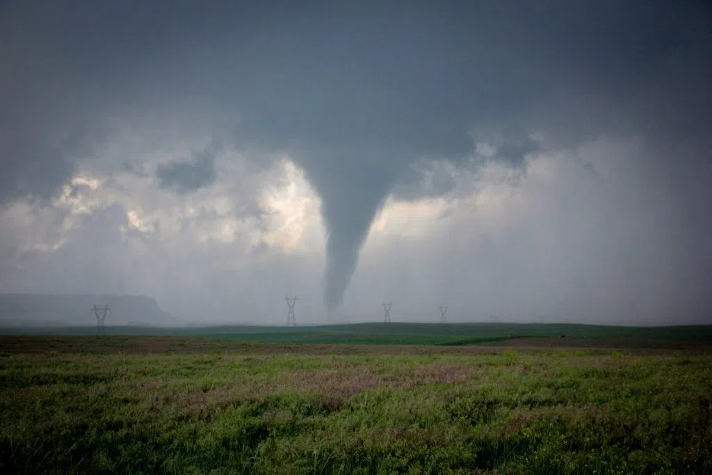
A brief tornado occurs near Hawk Springs, Wyo., during the evening of June 23, 2023, (Brian Neben, Courtesy)
That chase had been my last-ditch attempt to see tornadoes after several frustrating misses, but I had been able to close out 2023 on a positive note.
I only storm chase as a hobby and often only hit the road a handful of times per year, so there are no guarantees of what I will be able to witness.
When the spring season approaches, I always have doubts if I will be able to continue adding to my tornado tally. As the 2024 season approached, I wondered what it would hold.
The long-range forecast models had been hinting that this season would be far more active as the El Nino pattern in the Pacific Ocean was starting to weaken. Other seasons that had been in the same pattern had seen an uptick in severe weather.
My first chase of the year proved to be an embarrassing dress rehearsal.
——————————————————————————————————————————————————————–
On Sunday, March 24, Palm Sunday, a system was ejecting from the Rockies that looked to impact the Southern Plains. It was the first real reachable chase destination for me, and I wanted to shake off the rust.
I targeted southern Kansas due to the wind profile, but I should have known that the dewpoints were going to be too low.
I ended up targeting Pratt, Kan. and later moved further south to Medicine Lodge, Kan. as I awaited scattered storms coming up from the south. However, the lack of moisture effectively strangled the storms, and they never were able to strengthen.
Thanks to the low cloud deck, I couldn’t even take any meaningful pictures. So, I had effectively driven within 30 minutes of the Oklahoma border for gas and had nothing to show for it.
I drove home embarrassed about my forecasting skills, but it was still just the start of the season, and I felt like I could shake off one bad chase.
My next major outing wouldn’t come until the end of April and there looked to be several days of severe weather in store.
———————————————————————————————————————————————————————-
A system would be ejecting from the Rockies and on Thursday, April 25, the target looked to be northwest Kansas. This initial low pressure system would then pass over Nebraska on Friday, April 26 and a second system would impact the southern Plains on Saturday, April 27.
Each day held the possibility of severe weather, and my plan was to chase on Thursday, work on Friday and then hit the road again for Saturday. If I had been paying attention, I would have looked at Friday much more closely.
However, with my eyes set on Thursday, I targeted the warm front ahead of the upper-level low pressure area that would be making its way toward northwest Kansas.
I made the decision to make Oakley, Kan., a staging point and arrived in town in the early afternoon.
It was obvious that other storm chasers had the same target in mind, and we had all chosen the same gas station at the edge of town to wait for storm initiation. There were vehicles of all kinds, some decked out in equipment with license plates from Texas, Minnesota and Wisconsin to name a few.
Around 3 p.m., the first storm of the day began to initiate along the Colorado-Kansas border along the Interstate 70 corridor. I didn’t waste any time headed west toward Goodland, Kan., preparing to cut the storm off as it passed north of town.
On radar I could tell several updrafts had formed and they seemed to be in the process of merging together to form one larger storm. By the time I had gotten north of Goodland, I could see some of the structure I look for in a storm, the updraft base and precipitation core falling to its northeast.
I was able to keep in close proximity to the strengthening storm thanks to Highway 27. By now the storm was starting to form some wall clouds and I could tell a few rear flank downdraft bursts had occurred.
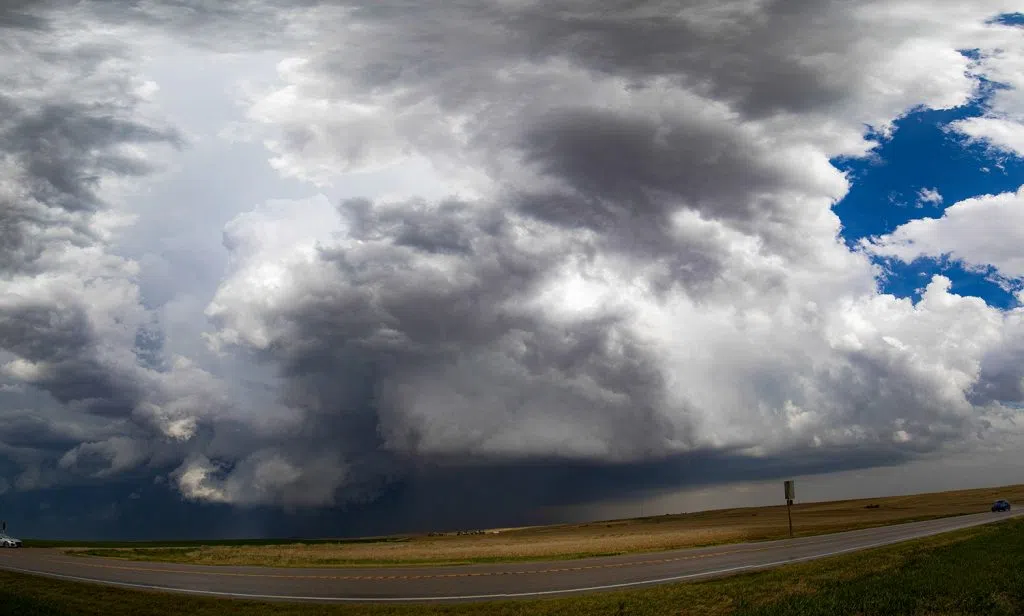
A supercell cycles north of Goodland, Kan., during the afternoon of April 25, (Brian Neben, Courtesy)
It was still early in the storm’s life but it was encouraging to see the supercell processes starting to take shape.
There was one funny moment during this chase, when a storm chasing tour parked near me when I had stopped to observe the storm.
One of the women in the group asked the tour guide why more chasers were not using the gravel roads around the storm.
The guide’s response made me laugh, he turned to her and said, “Storm chasers aren’t that stupid.”
He was alluding to the fact that gravel roads around storms can become great places to get our car stuck when it has been raining and I’ve found the backroads of western Kansas are particularly notorious for turning into a clay soup in a heavy rain.
I also enjoyed his insinuation that most chasers have to be just a little insane to partake in this hobby.
While I was near the tour group, I saw what was likely the storm’s best chance at producing a tornado, in fact it did, but I was on the backside of the storm and unable to get eyes on it.
However, the tornado in question was a narrow needle of a funnel that was hardly worth writing home about.
I continued north and began heading east for Bird City, Kan., which had been in the path of the tornado warned storm. To the east of town, I saw what was likely one of the last attempts to form a wall cloud, which turned out to be meager at best.
Once you’ve been chasing for half a decade, you tend to get a sense for which storms could produce a tornado, and which are just not tapping into the right ingredients.
I eventually had to call the chase due to the novel issue of fog that was forming around the storm. I suspect the cold outflow from the storms depressed temperatures right to the dewpoint and the moisture condensate.
My thoughts on this chase were mixed, but I hardly had time to catalogue this chase because Friday, April 26 happened.
———————————————————————————————————————————————————————
In hindsight I should have paid more attention to Friday, a low-pressure system moving directly over Nebraska, dewpoints still high from the system drawing moisture up from the south. However, I thought the better show would be on the Iowa-Nebraska border and in that respect, that verified in a major way.
I was at work in Kearney and wasn’t even paying attention to the weather, until a severe thunderstorm warning was paged out over the airwaves.
I stopped what I was doing to see what I was missing, and the radar showed a severe warned thunderstorm that had developed near Ravenna in northern Buffalo County.
I noted that the storm was already beginning to take on the pendant shape that is common to supercells. With an upper-level area of low pressure tracking over central Nebraska, I knew it wasn’t out of the question for storms to form right off the surface low that had also tracked into the area.
A storm showing these features so early in its life cycle sent my mental alarm bells ringing and I jumped in the car and drove for Ravenna as fast as I could.
I headed east out of Kearney as fast as I could and as soon as I could get a better view of the thunderstorm, there were signs that this one might be special. The first thing I noticed was the overshooting top above the anvil cloud.
An overshooting top represents a very strong updraft and hence a higher potential for severe weather with that storm. The updraft is forcing air parcels above a stable layer of the atmosphere.
Before I turned north on Ravenna Road, the National Weather Service – Hastings issued a tornado warning due to the strengthening mid-level rotation the cell was beginning to exhibit.
I drove north and tried to make out the general storm structure, but this was not so easy due to a myriad of low-level clouds surrounding the storm.
I arrived in Ravenna around 12:25 p.m. and the bridge over the railroad tracks gave me a better vantage for a moment. I could clearly see a more compact area of rotation that I felt could have been a tornado cyclone, but I wouldn’t know for sure until I got my eyes on the base.
On the north side of town, I passed one Ravenna Volunteer Fire Department grass rig and was following a second as they headed north outside of town.
As I drove north out of Ravenna, I could see a compact mesocycle just above a farmstead that was blocking my view of what was under it. The tension began to rise as rounded a slight bend on Highway 68 until I could finally get my eyes on the entire northern horizon.
Then it appeared.
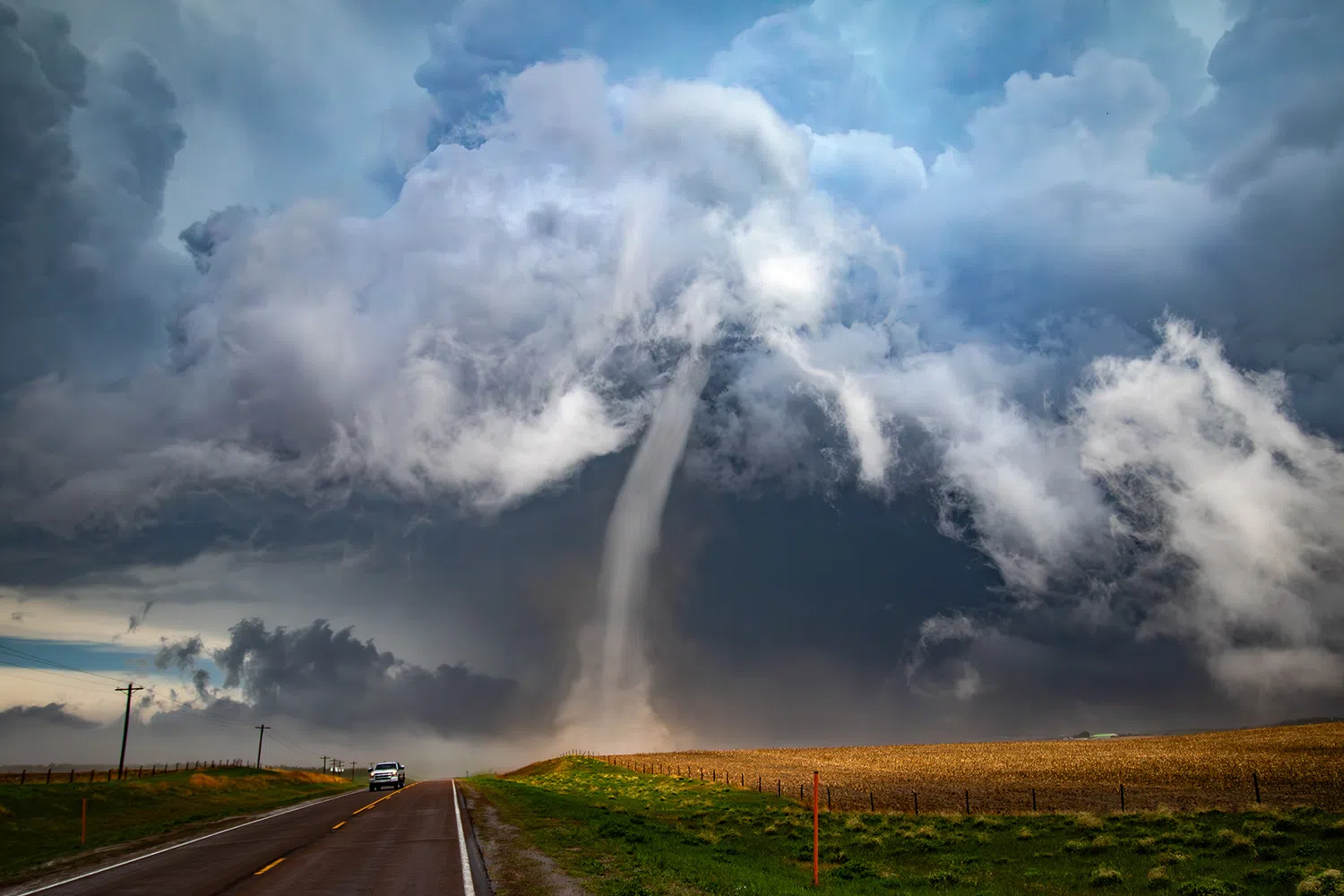
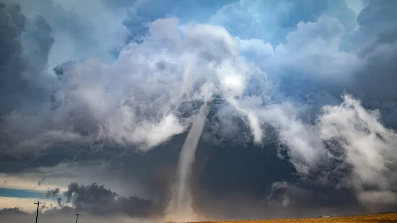
Descending out of a mass of swirling white clouds was a narrow rope tornado, stark white in brilliant contrast against the darker clouds behind it.
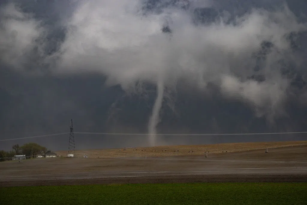
The EF-1 tornado passing north of Ravenna in Sherman County, (Brian Neben, Central Nebraska Today)
For a moment, I thought the tornado would dissipate due to its appearance. But slender twister kept planted over the farmland of Sherman County.
As I got closer, I could make out more details of the tornado, the fact that it was a nearly translucent inner funnel, surrounded near its base by a cylinder of condensation.
I finally got close, to within less than a quarter of a mile of the tornado after I could finally see its base which had been blocked by the terrain. Thinking this was close enough I pulled the car off to the side of the road and grabbed my camera.
Opening the door, I was greeted by a howling wind from behind that was feeding into the tornado. The base of the tornado began to turn a light brown as it picked up dust from the field it was moving over.
This was by far the closest I have ever been to an ongoing tornado. I distinctly recall that as I watched the tornado shift near the highway, my lizard brain was screaming at me to get away from the monster in front of me.
As the tornado began to cross the highway, it seemed to lose all strength, and the funnel faded quickly. It was a captivating and eerie sight to witness as the dust fell away but a ghost of a funnel could be seen for just a few moments more.
When I got sat back down in my car, I realized how badly my hands were shaking. The rush of adrenaline had been intense, and I could hardly dial the phone to make a report to the National Weather Service in Hastings.
Those on the other end of the phone probably thought I was coming off of a manic episode, I barley had control of the volume of my voice.
After doing my due diligence, I kept heading north to keep up with the storm. At a junction I turned east, heading toward Rockville.
I didn’t know it at the time and couldn’t see it from my location, but the storm had produced a second tornado that caused damage on the eastern side of Rockville.
As I began to head southeast on Highway 58, I suddenly became aware of damage that occurred in the area of Rockville Avenue.
This was also the first in my five years of chasing I had yet to run across tornado damage.
As I drove up Rockville Ave. I noticed large broken tree limbs, parts of a metal building that were in pieces and blown into the tree line. Eventually I could go no farther because a large tree had been blown down across the roadway.
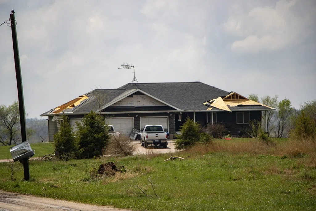
A Rockville residence damaged by an EF-1 tornado on Friday, April 26, (Brian Neben, Central Nebraska Today)
I’ve seen photos of tornado damage before, but to witness it firsthand was bizarre. I looked around and here was a piece of metal setting hanging over a power line as though it was laundry out to dry, over here was a power line that had been snapped at the base, but thanks to the tension of the wires, was now hanging among the tree limbs.
My heart dropped when I saw a home on the edge of Rockville had suffered damage to the edges of its roof, with the bare trusses showing in places. I chase to see tornadoes, but I never want to see them damage people’s property and lives.
On scene, I made the decision to end the chase and begin documenting the damage in my capacity as a local reporter.
In hindsight, I wish I had kept chasing the storm, which would produce three more tornadoes including an EF-3 tornado near Elba and two EF-2 tornadoes near Wolbach and Primrose.
The supercell that spawned the Ravenna tornado would just be the first of the day. A tornado outbreak would follow in eastern Nebraska when 25 tornadoes would occur in eastern Nebraska and western Iowa.
Notable tornadoes included the Lincoln/Waverly EF-3 that was documented live on air by Lincoln television stations, the Elkhorn/Bennington/Blair EF-4 that caused significant damage in the area and the Minden/Harlan Iowa EF-3 that killed one person.
The Ravenna tornado I witnessed would be rated EF-1 and traveled 4.76 miles with peak winds of 90 mph. I was the first April tornado I have ever witnessed and the earliest in the day at 12:30 p.m.
To see the impact and destruction this outbreak caused was shocking and left somewhat of a bitter taste in my mouth. There is part of me that wished I could have witnessed more of what was a historic tornado outbreak in my home state.
But on further reflection, I think I should be content that the tornado I was able to lay eyes on caused no damage as it wandered over rural farmland.
I can say I was able to see the first tornado that touched down as a part of the April 26 outbreak.
I ended up not chasing on Saturday, the close range approach of the Ravenna tornado had been enough to satisfy the adrenaline junkie in me for the moment.
———————————————————————————————————————————————————————-
Prior to 2024, I had never seen tornadoes on two different days within the same season. That would be another first I would set during the remarkable severe weather season.
Following a chase where I documented a high precipitation on the High Plains of northeast Colorado earlier in the week, severe weather was back on the table as early as Thursday, May 23.
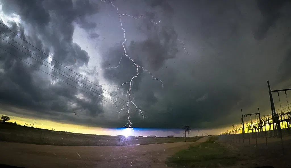
A cloud-to-ground lightning strike takes place near Akron, Colo., on May 20, (Brian Neben, Courtesy)
I did have my eyes on this day, but I was expecting storms to take on a more linear structure as a cold front swept through western Nebraska. Tornadoes can occur with these structures, but they are rarer and not nearly as photogenic.
I took a wait and see method on Thursday and even as storms began to fire west of Ogallala, near the Colorado-Nebraska state line, I held my ground to see what would play out. There were a few initial tornado warnings but even that didn’t move me at first.
My forecasting skills were again humbled when I checked the radar later in the afternoon. Storms were indeed taking on a linear structure, but the cells on the southern edge of the line would take on supercell characteristics and began to pose a threat for tornadoes.
I had a rude wakeup call when multiple tornado reports began to come in from Lake McConaughy and in Keith County.
Enough sitting on my hands, I peeled out of the driveway and made my way west.
I jumped off at Gothenburg and headed down to Farnam before heading west through Curtis and Maywood, before arriving at Highway 83. Given the southern developments of the storms, I needed to keep going south.
I was looking for a high enough vantage point so I could see the entire western sky and finally found a suitable spot on Road 732, just north of Hugh Butler Lake.
My view to the northwest was dominated by a large shelf cloud, indicating the edge of the line of storms, there was enough daylight spilling through to create an orange contrast to the west. To the southwest was the newest updraft, contrasted against the blue sky.
I had thoughts of getting closer to the base of the storm, but given the continual southward development of the complex and the fact there are not many ways to bail east off of Highway 83 before McCook, I made the decision to hold my ground and let the storm come to me.
Looking off to the northwest, I could tell an embedded supercell feature was starting to gain more rotation and this was confirmed a few minutes later when the National Weather Service – North Platte issued a tornado warning for the region.
From my position I could see what looked to be a wall cloud lower form, which was contrasted perfectly against the orange glow of the setting sun.
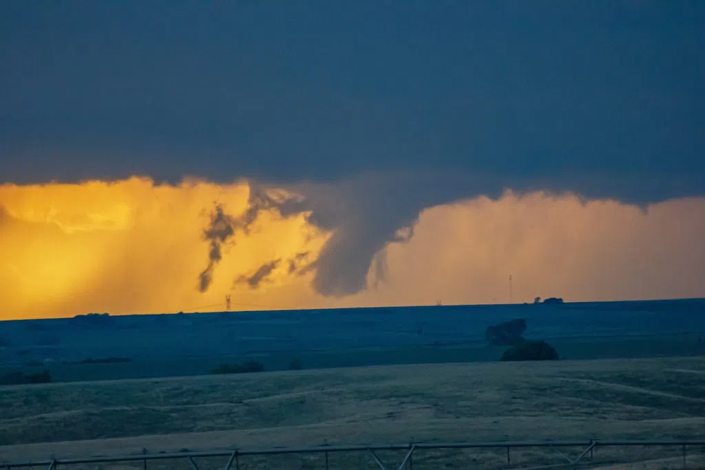
A brief EF-U tornado occurs in rural Hayes County during the evening of May 23, (Brian Neben, Courtesy)
A distinct funnel persisted for several minutes before it faded away. However, there seemed to be a second attempt at a funnel before the feature washed out completely as the storm cycled.
Sharing my video and photos with NWS North Platte, they confirmed I had indeed seen a brief tornado, the eighth of nine that would be reported in their county warning area. The tornado would be classified as an EF-U due to no indications of damage.
My two tornado encounters of 2024 couldn’t have been different.
I went from being less than a quarter of a mile from the Ravenna EF-1 tornado on April 26, to seeing the Hayes County EF-U from at least 20 miles away.
The May 23 tornado also brings my total witnessed tornado count as a chaser up to 12.
This chase held another unique moment when later I was in McCook as a tornado warned supercell bared down upon the town.
The site to the west was awe inspiring – the wind sculpted updraft of a supercell rising into an anvil cloud that covered everything overhead. Near the surface was the rear flank gust front that merged into the shelf cloud of the rest of the storm complex.
And lightning, seemingly constant lightning, flashing nearly every place of the storm.
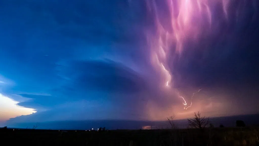
A tornado warned supercell approaches McCook during the evening of Thursday, May 23, (Brian Neben, Central Nebraska Today)
As if it was an orchestra cueing up a suspenseful score for a tense scene, the tornado sirens in town began to blare and I could hear the tone carried on the wind.
McCook was able to miss an impact from and EF-1 tornado formed near old Highway 34 west of Trenton and moved to the southeast damaging a few structures, trees and light poles around the football field and track.
A second brief tornado did occur five miles west of McCook, but it remained over open country and was rated EF-0.
This chase proved an excellent reminder that a variety of atmospheric environments can be conducive to producing tornadoes.
While I witnessing a tornado at 20 miles isn’t quite the same as one that is right in your face, its still remarkable that I might have been the only person in the area to witness the brief twister.
If a tornado occurs in the Plains and no one sees it, did it really happen?
That’s what storm spotters are for.
———————————————————————————————————————————————————————-
I had several other chases later in the season where I made close approaches to tornado warned supercells, but I would only document tornadoes on April 26 and May 23.
In retrospect, 2024 was a year of several firsts for me.
It was the earliest in the year I have witnessed a tornado and the earliest in the day, only 30 minutes afternoon. I made the closest approach I have ever made to a twister, while also viewing one at over 20 miles.
My encounter with tornado damage in Rockville was another novel experience for me. It left a strong reminder of the power of Mother Nature and how little time it takes for everything to be turned on its head.
This was also the first year I had seen tornadoes on two different dates. I have witnessed multiple tornadoes in one evening before, May 17, 2019, and June 23, 2023, but it felt like progress to get multiple days with at least one tornado.
As winter approaches, I have the urge to hibernate until the dewpoint reaches back into the upper 50s. However, I always spend the colder months wondering what next spring will bring.
It’s almost a given that spring 2025 will be somewhat quieter than 2024, which was the most active since 2011. I never take witnessing a tornado for granted and wonder if I will be able to do so again next year.
Until then, I’ll do my best to appreciate the season in front of me and wait until lightning crackles and thunder roars.
Editor’s Note: My name is Brian Neben and this is my sixth year as storm spotter and chaser. I write a personal column about each outing, as it helps to collect my thoughts and I have felt like people enjoy reading about my success or failures perusing this rather niche hobby.
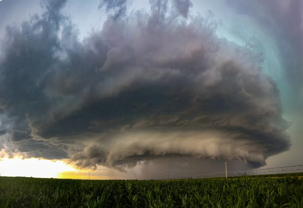
The tornado warned supercell as it approaches the community of Minden during the late afternoon of July 6, (Brian Neben, Central Nebraska Today)

